 |
||
|
|
||
|
Page Title:
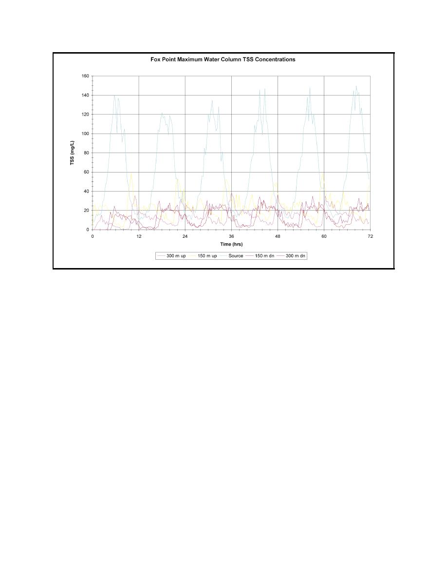
Figure 10. Time history of maximum water column TSS concentrations with bucket release rate of 4 percent at the Fox Point Rea... |
||
| |||||||||||||||
|
|
 ERDC TN-DOER-E12
July 2000
Figure 10. Time history of maximum water column TSS concentrations with bucket release rate of 4 per-
cent at the Fox Point Reach Central (FPRC) site. Also shown are TSS concentrations of 150 m
(500 ft) and 300 m (1,000 ft) up and down chane of the site
In summary, dredging in the Fox Point Reach results in the largest TSS concentrations. This is
because the available water volume for dilution of the sediment plume is smallest. Results due to
dredging in the Bullock Point Reach South and Rumstick Neck Reach are similar since they do not
appear to be limited by available water volume for dilution.
Using a 2 percent bucket release rate, a series of plumes generated simultaneously at multiple
dredging sites was also simulated. Figure 13 shows both plan views of maximum concentrations
computed during the simulation at a depth of 8-10 m (26-33 ft) and vertical section views with
dredging occurring at both the Fox Point North (FPRN) and Central (FPRC) locations. The
maximum extent of the plumes from each site overlap into each other at concentration levels less
than 7 mg/L. The up and down channel extents of the plumes are similar to the case of a single
release in that the second release does not significantly influence the concentrations on the other
side of the first release site. The maximum concentrations at both sites occur near the bottom at a
depth of 8-10 m (26-33 ft) with concentration levels in the 55-148 mg/L range. The extent of the
maximum concentration plume greater than 3 mg/L at 9 m (30 ft) is approximately 2.3 km (1.4 mi).
There are only two relatively small locations with concentrations greater than 20 mg/L surrounding
the release sites.
Figure 14 shows both plan views of maximum concentrations computed during the simulation
located at a depth of 8-10 m (26-33 ft) and vertical section views for the case of dredging occurring
simultaneously at both the Fox Point Reach Central (FPRC) and Fuller Rock Reach Central (FRRC)
14
|
|
Privacy Statement - Press Release - Copyright Information. - Contact Us - Support Integrated Publishing |
